Pacific Coast
Highway
San Francisco to Los Angeles on the road that invented the American coastal drive. Big Sur cliffs, Monterey otters, Hearst Castle excess, Santa Barbara sun, and a Malibu ending that Hollywood couldn't improve on.
Route Overview
The Pacific Coast Highway is the most famous coastal drive in America, and it earns the reputation through brute force scenery. Highway 1 hugs the California coastline from San Francisco to Los Angeles, and the stretch through Big Sur, where the Santa Lucia Mountains drop straight into the Pacific with nothing between the road and the ocean except a flimsy guardrail and several hundred feet of air, is the section that appears in every convertible advertisement ever filmed.
The drive is 750 kilometres in total, but the daily distances are short enough that you spend more time out of the car than in it. This is important because what happens at the stops, from the Monterey Bay Aquarium's sea otters to the absurd grandeur of Hearst Castle to the sunset at Santa Barbara's Stearns Wharf, is the actual trip. The driving connects them, and the driving is spectacular, but trying to rush through to reach LA defeats the entire purpose of being on this road.
California is expensive. This is not a budget roadtrip. Big Sur has limited accommodation at premium prices. Fuel costs more than almost anywhere else in the US. But the coast itself is free, the viewpoints are free, and the light at golden hour on the Big Sur cliffs is worth whatever the hotel cost.
The Itinerary

The City and the Surf Town
If you have a morning in San Francisco before picking up the car, the Golden Gate Bridge on foot (thirty minutes each way) and a coffee in the Mission District are the two things worth doing. Pick up your rental and head south on Highway 1 through Half Moon Bay (good for a brunch stop, especially Sam's Chowder House if you like crab) and down through the agricultural coast to Santa Cruz.
Santa Cruz is a university surf town with a vintage boardwalk that has the oldest operating roller coaster in California (the Giant Dipper, 1924, wooden, terrifying). West Cliff Drive is a walking and cycling path along the cliffs where you can watch surfers at Steamer Lane, one of the best surf breaks in Northern California. Natural Bridges State Beach has tide pools and a natural rock arch. The town has the laid-back, slightly scruffy energy of a place that prioritised surfing over commerce and doesn't regret the decision.
- Half Moon Bay - Coastal town, brunch stop, pumpkin farms in autumn. Sam's Chowder House for Dungeness crab.
- Santa Cruz Beach Boardwalk - Classic seaside amusement park. Giant Dipper roller coaster (1924). Free entry, pay per ride.
- West Cliff Drive - Coastal path with surfer views at Steamer Lane. Walking, cycling, or just watching.
- Natural Bridges State Beach - Tide pools, rock arch, monarch butterflies (Oct-Feb). $10 parking.
Otters, Canneries, and Fairytale Cottages
Drive to Monterey, where the main event is the Monterey Bay Aquarium. This is not a typical aquarium. The sea otter exhibit alone is worth the $55 entry. The kelp forest tank is a full-storey window into the ocean. Budget three hours minimum. Cannery Row, the waterfront street that Steinbeck wrote about, is now restaurants and tourist shops, but the harbour with its sea lions barking on the docks is genuine.
The 17-Mile Drive ($11.25 toll) is a private scenic road through Pebble Beach with views of Lone Cypress, Bird Rock, and mansions that make you reconsider your career choices. Continue to Carmel-by-the-Sea, a village that is almost absurdly charming: fairytale cottages, no street addresses by design, over 100 art galleries, and a white-sand beach backed by Monterey cypress trees. Sunset at Carmel Beach with the cypress silhouettes is the photograph that makes people book this trip.
- Monterey Bay Aquarium - World-class. Sea otters, kelp forest, open sea exhibit. $55 adults. Book online. Allow 3+ hours.
- 17-Mile Drive - Private toll road ($11.25). Lone Cypress, Pebble Beach golf, coastal mansions, Bird Rock.
- Cannery Row - Steinbeck's waterfront. Restaurants, sea lions on the docks, harbour walks.
- Carmel Beach - White sand, cypress trees, sunset. No leash law for dogs. No street numbers in town. Genuinely charming.

The Main Event
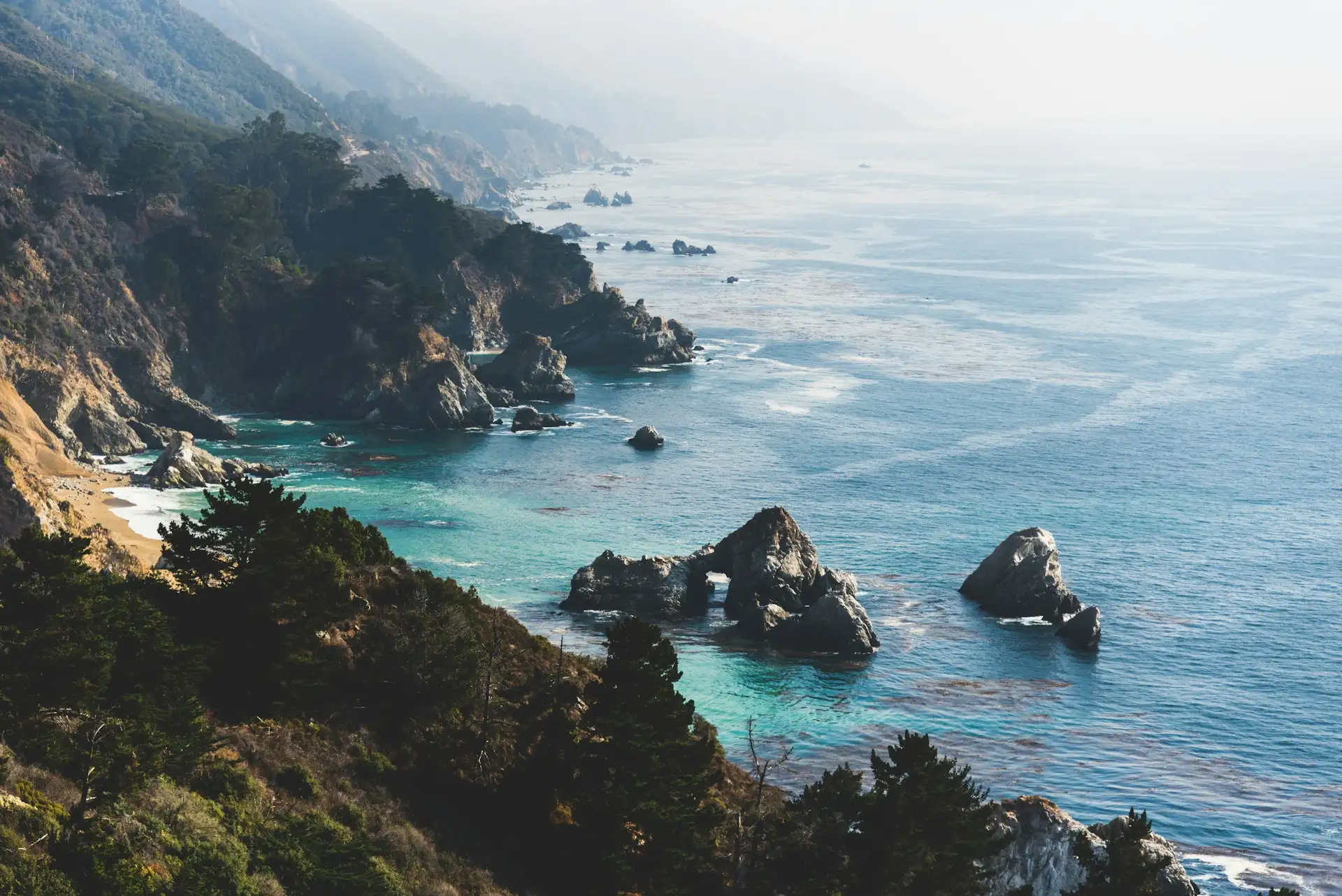
Big Sur is the reason this roadtrip exists. The ninety-mile stretch where the Santa Lucia Mountains meet the Pacific is not a town, it's a region, and the road through it is simultaneously one of the most beautiful and most nerve-wracking drives in America. The cliffs drop hundreds of feet to the ocean. The road clings to the mountainside. There are no guardrails in some sections. The fog rolls in and out. Every pullout has a view that makes you stop the car.
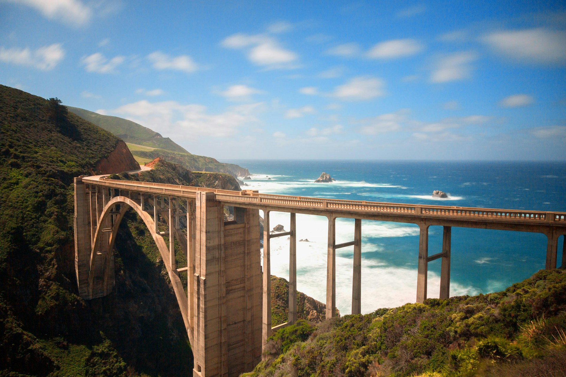
Bixby Bridge, eight miles south of Carmel, is the photograph: a 714-foot concrete arch spanning a canyon with the Pacific behind it. McWay Falls, further south in Julia Pfeiffer Burns State Park, is an 80-foot waterfall that drops directly onto the beach (viewable from the overlook trail, ten minutes). Pfeiffer Beach has purple sand from manganese garnet and a keyhole rock formation that frames the sunset in December and January. The Point Sur Lighthouse sits on a volcanic rock connected to the mainland by a sandbar. Big Sur has extremely limited accommodation (book months ahead) and no cell service in most areas, which is either a problem or a feature depending on your relationship with your phone.
- Bixby Bridge - The most photographed spot on the PCH. Pullout on the north side. 714-foot span above a canyon.
- McWay Falls - 80-foot waterfall onto a beach. Julia Pfeiffer Burns SP. 10-minute trail to overlook. $10 parking.
- Pfeiffer Beach - Purple sand, keyhole rock. Take the unmarked Sycamore Canyon Road turnoff. $12 parking. Arrives via dirt road.
- Nepenthe Restaurant - Cliffside restaurant with 800-foot elevation views. The ambrosiaburger is legendary. The view is the reason.

Elephant Seals and a Castle
Continue south through the remaining Big Sur coastline. Stop at the Piedras Blancas Elephant Seal Rookery, where hundreds of massive elephant seals lie on the beach in various states of torpor. The males weigh up to 2,500 kg and the sounds they make are unforgettable. Best viewing December to March (breeding season), but seals are present year-round. The viewing is free, from a boardwalk above the beach.
Hearst Castle sits on the hilltop above San Simeon. William Randolph Hearst built 165 rooms, two pools (the Neptune Pool is the one in the photographs), and filled the place with European art and antiquities that he purchased with newspaper money. Tours are required (book ahead, $25-$30) and take about two hours. The excess is the point. Stay in nearby Cambria, a small town with Moonstone Beach (a boardwalk along the coast) and good restaurants at non-Big Sur prices.
- Elephant Seal Rookery - Piedras Blancas. Hundreds of seals on the beach. Free viewing from boardwalk. Best Dec-Mar.
- Hearst Castle - 165-room hilltop estate. Neptune Pool. Guided tours required, $25-30. Book ahead online.
- Cambria - Small coastal town. Moonstone Beach boardwalk. Art galleries. Good dinner options at reasonable prices.
- Ragged Point - Cliffside viewpoint with a short trail to a cove. Last dramatic Big Sur view heading south.

Wine Country and Clam Chowder
Detour inland to Paso Robles if you like wine. The region has over 200 wineries and is known for bold Zinfandels, Cabernet Sauvignons, and Rhone-style blends. Many offer free or low-cost tastings ($10-20) in a setting that's significantly less pretentious than Napa Valley. Eberle, Tablas Creek, and Justin are names worth seeking out. If wine isn't your thing, skip the detour and head straight to the coast.
Pismo Beach is a classic California beach town in the way that means it hasn't been entirely overrun by money. The pier is the centre of gravity: fish and chips at the end, sunset views, and pelicans diving for dinner. Splash Cafe, which has been serving clam chowder in sourdough bread bowls since 1991, has a queue most days because the chowder is that good. The Oceano Dunes just south of town are one of the few places in California where you can drive on the beach (ATV rentals available). Accommodation here is significantly cheaper than Big Sur or Carmel.
- Paso Robles Wine Country - 200+ wineries. Zinfandel, Cabernet, Rhone blends. Tastings $10-20. Less pretentious than Napa.
- Pismo Beach Pier - Classic California pier. Sunset views, pelicans, fish tacos. The pier itself is the attraction.
- Splash Cafe - Clam chowder in sourdough bowls. The queue is the review. Cash or card.
- Oceano Dunes - Drive-on beach and sand dunes. ATV rentals. One of the last drive-on beaches in California.
The American Riviera
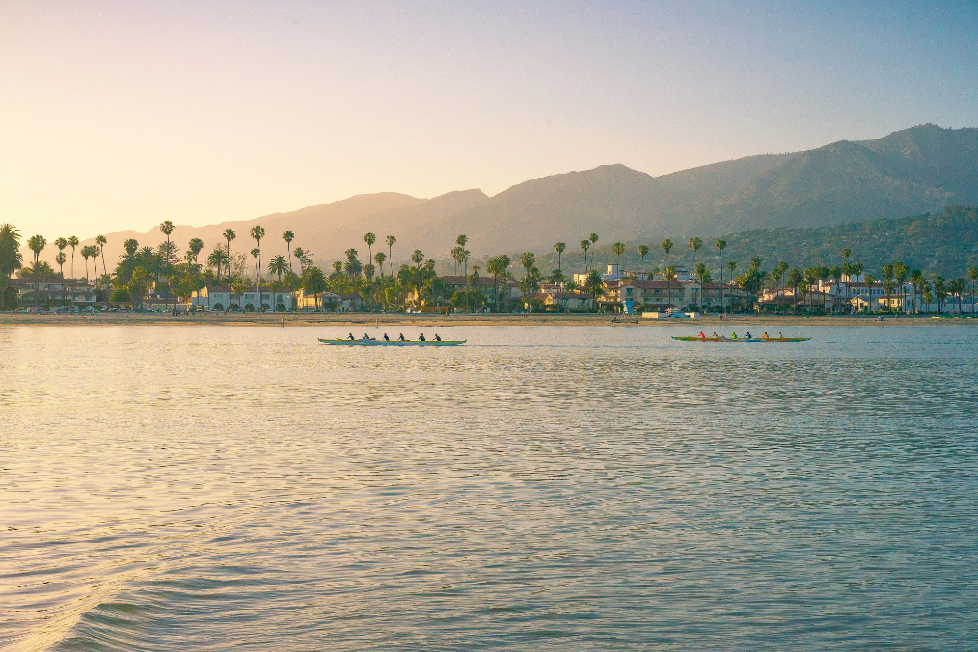
Santa Barbara calls itself the "American Riviera" and the comparison is not ridiculous. The climate is Mediterranean. The architecture is Spanish colonial (white stucco, red tile roofs, the result of a 1925 earthquake that destroyed the town and a subsequent rebuilding plan that insisted on a consistent aesthetic). The mountains rise directly behind the coast, creating a natural amphitheatre that faces the ocean.
The Mission Santa Barbara (1786, "Queen of the Missions") is beautiful and worth an hour. State Street is the main drag: restaurants, shops, tasting rooms for the Santa Ynez Valley wineries (the ones from the film Sideways). Stearns Wharf is the oldest working wharf on the West Coast and the place for sunset. Butterfly Beach in neighbouring Montecito is where the money lives (Oprah, Harry and Meghan, etc.) and the sand is genuinely excellent. Santa Barbara has a more refined, grown-up energy than the rest of this trip, which makes it the right penultimate stop before the chaos of LA.
- Mission Santa Barbara - 1786. "Queen of the Missions." Beautiful grounds, museum, gardens. $15 adults.
- State Street - Main street. Restaurants, wine tasting rooms, Spanish colonial architecture, evening scene.
- Stearns Wharf - Oldest working wharf on the West Coast. Sunset viewpoint. Restaurants. Free to walk.
- Butterfly Beach - Montecito's beach. Excellent sand. Celebrity-adjacent. East-facing, which means morning sun is best.

Malibu and the Finish Line
The final stretch takes you through Malibu, which is both a real town and a concept that the entertainment industry has been selling the world for decades. The reality: a 27-mile strip of coast where the mountains come close to the ocean, celebrity homes line the beach (you can't see them from the road, which is the point), and the surf breaks are genuinely world-class.
El Matador State Beach is the stop that doesn't appear in every guidebook but should: dramatic sea stacks, caves, and a beach reached by climbing down a cliff (steep stairs, manageable). Point Dume is a headland with a trail that gives panoramic views and, in winter and spring, whale-watching opportunities. Zuma Beach is the classic Malibu beach if you want wide sand and good waves. Continue into LA and end at Santa Monica Pier, the official western terminus of Route 66, or Venice Beach if you want your trip to end with street performers and Muscle Beach. Return your car. You just drove one of the most famous roads in the world, and you understand why it's famous.
- El Matador State Beach - Sea stacks, caves, dramatic cliffs. Steep stairs down. $8 parking. Less crowded than Zuma.
- Point Dume - Headland trail. Panoramic coast views. Whale watching Dec-Apr. Free.
- Santa Monica Pier - Route 66 terminus. Ferris wheel, arcade, sunset views. The classic LA ending.
- Venice Beach - Boardwalk, Muscle Beach, street performers, skate park. LA in its most unfiltered form.
Must-See Locations
Three places on this route stay with you. You'll show people the photographs and they'll book the same trip.

Bixby Bridge
714-foot concrete arch above a canyon with the Pacific as backdrop. The most photographed point on the entire PCH. Pull over on the north side. It looks exactly like the pictures, which is the rare case where reality matches the brochure.

McWay Falls
An 80-foot waterfall that drops directly onto a beach in a sheltered cove. One of only two tidewaterfalls on the California coast. Viewable from a short trail above. The water is turquoise. The scene is impossible. It is real.

17-Mile Drive
Private toll road through Pebble Beach. Lone Cypress, Bird Rock, coastal mansions, and Monterey cypress forests. $11.25 well spent. The Lone Cypress has been standing alone on its rock for 250 years and looks exactly like you'd expect.
Driving & Road Conditions
Highway 1 is well-maintained but narrow, winding, and occasionally closed. The Big Sur section is the most dramatic and the most demanding. Take your time. Use pullouts. Do not try to photograph from the driver's seat.
Car Choice
Any car works. A convertible is the classic PCH choice and genuinely enhances the experience when it's not foggy (which in June-July, it often is). Avoid oversized vehicles on the Big Sur section. Standard sedan or SUV is fine.
Road Closures
Highway 1 through Big Sur closes periodically due to landslides, especially after heavy rain. Always check BigSurCalifornia.org or Caltrans before driving. When closed, detour via Highway 101 inland. This adds time but is well-signed.
Fog
June and July mornings are often foggy along the coast (locals call it "June Gloom"). Fog typically burns off by midday. Plan Big Sur driving for afternoon when the light is better and the fog has cleared. September-October is the clearest.
Fuel
California fuel is among the most expensive in the US ($5-6/gallon). Fill up before Big Sur, where the single gas station charges significantly more. Fuel is available in all towns but sparse between Carmel and San Simeon.
Cell Service
No cell service through most of Big Sur. Download offline Google Maps before you leave. This is not optional. Navigation apps require pre-downloaded maps. Some accommodation in Big Sur has WiFi; most doesn't.
Pullouts & Safety
Use designated pullouts for photos. Do not stop on the road. Pull over for faster traffic behind you (it's the law in California and the polite thing to do). The road is narrow and RVs+cyclists share it. Drive defensively.
Essential Tips
🌞 Best Season
September-October is ideal: warm, clear, past the summer fog. April-May is good with wildflowers. Summer (June-August) is warmest but often foggy mornings. Winter has rain and possible Big Sur closures but dramatic light. Avoid summer weekends when the road is crowded.
🏨 Accommodation
Book Big Sur months ahead. Options are limited and expensive (Post Ranch Inn from $1,000+/night, Pfeiffer Big Sur State Park campgrounds from $35). Carmel and Cambria offer better value as bases for day-tripping into Big Sur. Santa Cruz and Pismo Beach are the budget-friendliest stops.
🍴 Food
Bring snacks and water for the Big Sur section (services are sparse and expensive). Splash Cafe clam chowder in Pismo Beach. Fresh seafood on Cannery Row. Mexican food everywhere (California does it well). In-N-Out Burger exists on this route and is a cultural obligation.
💳 Money
USD. Cards accepted everywhere. State park day-use parking is $10-12. Hearst Castle tours $25-30. Monterey Bay Aquarium $55. 17-Mile Drive $11.25. Tipping 18-20% at restaurants is expected. California tax is not included in displayed prices.
📷 Photography
Golden hour at Bixby Bridge. McWay Falls any time. Pfeiffer Beach keyhole rock at sunset (Dec-Jan the sun aligns through the arch). Carmel Beach at sunset. Point Dume for panoramic shots. Bring a polarising filter for the ocean glare.
👜 Packing
Layers. The coast can be 15°C in the morning and 25°C by afternoon, even in summer. Fog makes mornings cold. Sunscreen for afternoon sun. Comfortable shoes for coastal trails. Binoculars for wildlife. A sweater for Big Sur evenings.
Budget Planning
The PCH is not a budget roadtrip. California is expensive, Big Sur accommodation is limited and premium-priced, and fuel costs more than almost anywhere else in the US. That said, the coast itself, the viewpoints, the beaches, and the wildlife are free, and the sections south of Big Sur are significantly more affordable.
Book Your Trip
Everything in one place.
The Road That Invented the American Roadtrip
There are longer drives. There are cheaper ones. There are routes with more variety and routes with more solitude. But the Pacific Coast Highway is the drive that most people think of when they think of "roadtrip," and it earns that position by doing one thing better than any other road on earth: putting the ocean on one side, the cliffs on the other, and the sunset ahead of you.
The PCH doesn't need to be complicated. Pick up a car in San Francisco. Drive south slowly. Stop when the view demands it, which is constantly. Eat clam chowder. Watch otters. Drink wine. Photograph Bixby Bridge. Sit at Nepenthe with an 800-foot view and wonder why anyone commutes. Arrive in LA with a sunburn and a full camera roll and the quiet certainty that some roads are not just about getting somewhere.