Tajikistan
93% of the country is mountains. The Pamir Highway — the second highest road in the world — crosses four passes above 4,200 meters on the way to the Chinese border. The Wakhan Valley has the Hindu Kush on one side and the Pamirs on the other, with Afghanistan 50 meters across the river. This is a country that earns its reputation as one of the world's most extraordinary places to travel. It also earns its reputation as one of the most demanding.
What You're Actually Getting Into
Tajikistan is not a country you drift into. It requires research, permits, physical preparation, a tolerance for genuine discomfort, and the ability to adjust your plans when a road washes out, a shared taxi breaks down in a pass at 4,000 meters, or the guesthouse you expected to find in Murghab has run out of fuel for heating. These things happen. The travelers who return from Tajikistan describing it as one of the defining experiences of their traveling lives are the same people who accepted these conditions before they arrived and were not surprised when they materialized.
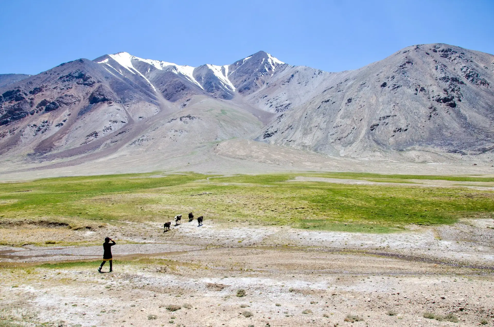
The Pamir Highway — the M41, second highest road in the world — runs approximately 1,200 kilometers from Dushanbe to the Kyrgyz border through landscapes that operate on a geological scale the human eye struggles to process. The Pamirs are one of the world's great mountain systems: the place where the Hindu Kush, Karakoram, Tian Shan, and Kunlun ranges converge. The plateau east of Khorog — the section of highway through Murghab toward the Chinese and Kyrgyz borders — is a high-altitude desert at 3,500–4,600 meters where the sky is a specific shade of blue that only exists at altitude and the distances between things are enormous.
The Wakhan Valley, branching south from the main Pamir Highway near Ishkashim, runs along the narrow strip of Afghan territory — the Wakhan Corridor — that separates Tajikistan from Pakistan. Across the river, Afghan farmers wave from their fields. You can see the Hindu Kush from the Tajik bank. Alexander the Great passed through this corridor. Marco Polo described the wildlife on the Pamir plateau, including the sheep that now bear his name (Marco Polo argali). This particular combination of history, geography, and sheer improbability is available to anyone who gets a permit and a reliable vehicle.
The Fann Mountains in the northwest are a different argument — more accessible from Dushanbe, with turquoise glacial lakes (the Seven Lakes trek is the most popular route), alpine valleys, and trekking that doesn't require the altitude acclimatization that the Pamirs demand. For travelers who want the essence of Tajikistan without the full Pamir commitment, the Fanns deliver almost everything: dramatic mountain scenery, village hospitality, and landscapes that appear in no other Central Asian country quite the way they appear here.
The honest caveats: Tajikistan is one of the poorest countries in the former Soviet Union. Infrastructure is limited and variable. The government of President Emomali Rahmon, in power since 1994, is authoritarian — press freedom and political opposition are effectively absent. The border with Afghanistan requires specific awareness (see safety section). Altitude sickness is a genuine medical risk that kills unprepared travelers. None of this has deterred the small but growing number of adventurous travelers who arrive each summer to drive, cycle, or walk one of the world's last great road journeys. Go prepared and it will deliver exactly what it promises.
Tajikistan at a Glance
A History Worth Knowing
The territory of modern Tajikistan sits at one of the great crossroads of Central Asian history — on the routes that connected China to Persia, India to the Mediterranean, and the steppe world to the settled civilizations of the south. The Silk Road ran through here. The ancient city of Penjikent in the Zarafshan Valley (just outside the modern city of the same name) was a major Sogdian trading center before its destruction by Arab forces in the 8th century CE — the Sogdians were among antiquity's greatest merchant peoples, whose commercial networks stretched from China to the Byzantine Empire, and whose wall paintings from Penjikent are some of the finest examples of pre-Islamic Central Asian art.
Alexander the Great crossed the Oxus (modern Amu Darya) river into Bactria — the territory of northern Afghanistan and southern Tajikistan — in 329 BCE, founding the city of Alexandria Eschate ("Alexandria the Furthest") at modern Khujand. He then pushed southeast through what is now the Wakhan Corridor toward India. The Greeks left a cultural presence in the region that fused with local Bactrian and Zoroastrian traditions over the following centuries, producing the syncretic Hellenistic-Buddhist art of Gandhara.
The Arab conquest of Central Asia in the 7th and 8th centuries CE brought Islam to the region. The Samanid dynasty — a Persian-speaking dynasty that ruled from Bukhara (in modern Uzbekistan) in the 9th and 10th centuries — is considered the first flowering of Tajik national culture and the period from which modern Tajik literary tradition descends. The poet Rudaki, considered the father of Persian literature, worked at the Samanid court in this period.
The Mongol invasions of the 13th century devastated the settled civilization of Central Asia, destroying cities, irrigation systems, and the accumulated intellectual heritage of centuries. Recovery was slow and partial. The region subsequently passed through Timurid, Shaybanid, and eventually Russian Imperial control. Russian forces reached the Pamir plateau in the 1890s, completing the "Great Game" expansion that gave Russia strategic control over the mountain passes overlooking British India — and creating the Wakhan Corridor as a narrow buffer of Afghan territory between the two empires, a geopolitical accident whose borders you can see from the road today.
Soviet rule from 1924 transformed Tajikistan dramatically: literacy was introduced at scale, infrastructure was built (the Nurek Dam, completed in 1980, was the world's tallest earthfill dam), and the cotton monoculture that depleted the Aral Sea basin was imposed on Tajikistan's lowlands. The Soviet Union drew national borders in Central Asia with deliberate complexity — Samarkand and Bukhara, historically Tajik-speaking cities, were assigned to Uzbekistan in a divide-and-rule policy that created tensions between the neighboring states that persist today.
Independence in 1991 was followed almost immediately by a devastating civil war between the Soviet-era government and an Islamist-democratic opposition coalition, lasting from 1992 to 1997 and killing an estimated 50,000–100,000 people in a country of 5 million. The war ended with a negotiated peace and the consolidation of power by Emomali Rahmon, who has ruled since 1994 and became President for Life by constitutional amendment in 2016. The political system is authoritarian but the country is stable. The civil war remains a living memory for the generation that survived it.
Crosses the Oxus into Bactria. Founds Alexandria Eschate at modern Khujand. Campaigns through the Wakhan Corridor toward India.
First golden age of Tajik-Persian culture. The poet Rudaki writes at the Samanid court. Penjikent and the Zarafshan Valley flourish.
Genghis Khan's forces destroy Central Asian cities and irrigation systems. Centuries of slow recovery follow.
Russian forces reach the Pamirs, completing their southward expansion. The Wakhan Corridor is created as a buffer between the Russian and British empires.
Tajikistan established as a Soviet republic. The border drawings that exclude Samarkand and Bukhara from Tajikistan create tensions that last to the present.
Estimated 50,000–100,000 killed. One of the deadliest post-Soviet conflicts. Ends with negotiated peace and the consolidation of Rahmon's rule.
Emomali Rahmon consolidates power. Declared President for Life by constitutional amendment in 2016. Country stable but politically closed.
Top Destinations
Tajikistan's destinations divide into two main circuits: the northwest (Dushanbe, Fann Mountains, Penjikent, Khujand — accessible without a GBAO permit) and the Pamir circuit (Dushanbe east to Khorog, Wakhan Valley, Murghab, Pamir Highway to the Kyrgyz or Chinese borders — requiring the GBAO permit). Most visitors doing a serious trip combine both. Budget at least two weeks; three weeks is better. The Pamir alone, done properly, takes 10–14 days from Dushanbe.
The Pamir Highway (M41)
The M41 runs from Dushanbe southeast to Khorog, then splits — the Wakhan route follows the Afghan border south before turning north through Langar and rejoining at Ishkashim, while the main highway continues east through Murghab to the Kyrgyz border at Kulma Pass (4,362m) or the Chinese border at Qolma Pass (4,336m). The section east of Khorog is the most dramatic: Alichur Valley at 3,900m, Yashilkul Lake reflecting the Pamirs, the Zorkul Nature Reserve for Marco Polo sheep, and the long empty road to Murghab where the scale of the plateau only becomes clear after several hours of driving with nothing on the horizon but mountains. This road is done by vehicle (most travelers hire or share a 4WD), by motorcycle, by bicycle (serious cycling only — days without services), and occasionally on foot for specific sections.
Wakhan Valley
The Wakhan is the single most geopolitically extraordinary valley in Central Asia — a 250-kilometer strip running along the Panj River, with Afghanistan directly across the water and the Hindu Kush rising immediately behind it. In places the river is 30 meters wide and you can see Afghan farmers and Wakhi communities on the other bank. The Tajik side has Ismaili villages, petroglyphs dating back thousands of years, Alexander-era fortress ruins (Yamchun and Khorog fortresses), hot springs at Bibi Fatima, and campsites with views of Noshaq (the highest peak in Afghanistan) and the Wakhan peaks of Pakistan. The valley dead-ends at the Wakhjir Pass into China at around 4,900 meters. Allow 3–5 days to do it properly.
Khorog
The capital of Gorno-Badakhshan — the GBAO region — sits at 2,200 meters at the confluence of the Gunt and Panj rivers. It is a small town of around 30,000 people that functions as the operational hub for the eastern Pamir: the last place before Murghab to stock up on supplies, find mechanics, exchange money, and connect with guesthouses and guides. The Aga Khan Development Network has invested significantly in Khorog's public spaces, schools, and health infrastructure — the Ismaili Muslim community of the Pamirs has a specific relationship with the Aga Khan Foundation that makes this region somewhat better-served than comparable areas in other poor mountain countries. The botanical garden above the town is excellent.
Murghab
At 3,650 meters above sea level, Murghab is the highest town in Tajikistan and one of the most remote inhabited places in Central Asia. The surrounding plateau — the Eastern Pamir — is a high-altitude desert of extraordinary barrenness, with Marco Polo sheep, yak herders, and the occasional Soviet-era military ruin. The town itself is a collection of concrete blocks and yurt guesthouses, with a lively market that serves the Kyrgyz and Pamiri communities of the plateau. Murghab is not a destination in itself — it is a way station and an altitude test. The nights here at 3,650 meters tell you how your body is handling the elevation before you climb higher.
Fann Mountains & Seven Lakes
The Fann Mountains in northwestern Tajikistan are the most accessible part of the country's high terrain — reachable from Dushanbe in a few hours, no GBAO permit required, and containing some of the finest alpine scenery in Central Asia. The Seven Lakes (Haft Kul) trek follows a series of glacially carved lakes — each a different shade of turquoise, blue, or green depending on sediment and depth — through valleys surrounded by peaks above 5,000 meters. Iskanderkul (Lake of Alexander, named for Alexander the Great who is said to have camped here) is the most celebrated single lake: a turquoise oval surrounded by dramatic cliffs with a waterfall at its outlet. Homestays in the surrounding villages are the accommodation standard.
Dushanbe
Tajikistan's capital is a Soviet-planned city of wide boulevards, heavy government architecture, and a pleasant enough tree-lined center that bears the marks of significant investment in presidential vanity projects — including a flagpole that was briefly the world's tallest at 165 meters and a gold-plated statue of the president's father that has been relocated after international mockery. The National Museum has genuinely excellent archaeological collections. The Rudaki Park and the adjacent restaurants and cafes constitute the most pleasant urban experience in the country. Dushanbe is primarily a logistics base and acclimatization point before heading east or north, but it rewards a day or two of genuine curiosity.
Penjikent & the Zarafshan Valley
The ancient city of Penjikent — a major Sogdian trading center destroyed by Arab forces in 722 CE and abandoned thereafter, preserved in the dry Central Asian air for 1,200 years — sits on a bluff above the modern town of the same name. The excavated ruins, with their mudbrick walls and the outlines of temples, palaces, and merchant houses, give a direct physical connection to the pre-Islamic Silk Road world. The Archaeological Museum holds extraordinary Sogdian wall paintings. The drive to Penjikent from Dushanbe follows the Zarafshan Valley past gorges and traditional villages. A further day trip reaches the Marguzor Lakes, a chain of glacially colored lakes below the Fann Mountains' western approaches.
Karakul Lake
At 3,914 meters altitude near the Chinese border, Karakul is one of the highest lakes in the former Soviet Union — a vast, dark expanse of water (the name means "Black Lake") formed by a meteorite impact an estimated 25 million years ago, surrounded by peaks of the Eastern Pamir. The lake is 380 square kilometers and almost perfectly round. The small settlement of Karakul on its western shore has basic guesthouses. The drive past the lake on the M41 toward the Kyrgyz border is one of the most visually striking sections of the entire Pamir Highway — the scale of the lake against the scale of the surrounding mountains is genuinely impossible to process at normal altitude; at 3,914 meters it becomes even more so.
Culture & Etiquette
Tajikistan is a Muslim-majority country, predominantly Sunni in the lowlands and west, with a distinctive Ismaili Muslim community in the Pamirs and Wakhan. The Ismaili of the Pamirs — followers of the Aga Khan, who has invested significantly in the region through the Aga Khan Development Network — have a more liberal social practice than Sunni communities: mixed-gender gatherings are normal, alcohol is not forbidden, and women participate more visibly in public life. The distinction between Pamiri and lowland Tajik social culture is significant and travelers moving between the two regions will notice it.
Tajik hospitality is genuine and generous to a degree that can feel overwhelming — the offer of food and tea is not perfunctory but an expression of actual care for the guest. In remote areas, stopping at a family's home and asking for shelter is a completely normal thing to do, and the expectation that you will be welcomed and fed is usually fulfilled. This hospitality culture imposes obligations in return: respect for the household, appropriate behavior toward women, and gratitude that is expressed through genuine engagement rather than just payment.
Without exception. The threshold of a Tajik home is the clearest boundary in the culture. Remove shoes, step over the threshold, and wait to be directed where to sit. In guesthouses that are private homes, the same applies. The gesture is noticed and appreciated every time.
Tea is served constantly — before conversation, during conversation, after conversation. Accept it with both hands or with the right hand, never just the left. A small bow or nod acknowledges the host. Refusing food entirely is impolite; accepting a portion and eating with evident pleasure is the ideal response.
Women should cover arms and legs outside Dushanbe's city center. The Pamirs are more relaxed about dress standards but modesty remains appropriate. Men: shorts are acceptable on treks; in towns and villages, long trousers are more respectful.
"Salom" (hello), "Rahmat" (thank you), "Mehriboni" (kindness — used to acknowledge hospitality), "Khush omaded" (welcome, said to guests). Russian is widely understood, particularly among older generations. Any Tajik in a rural area who hears you attempt Tajik will respond with visible pleasure.
Especially women. Older men will often pose enthusiastically; women and children in conservative communities may prefer not to be photographed. In the Pamirs, photography is more freely accepted but asking first remains respectful. Never photograph military installations, checkpoints, or border infrastructure.
Tajikistan has no free press and political criticism is prosecuted. This is not a theoretical risk for tourists, but expressing strong opinions about Emomali Rahmon or the government to people you've just met is imprudent and puts your hosts in an uncomfortable position. Political discussion is fine in private with trusted acquaintances; broadcasting views is not.
The Panj River border with Afghanistan is militarized on the Tajik side and border guards periodically check travelers. Photography near border posts, military vehicles, or the bridge crossing points requires caution and ideally explicit clearance. Watchtowers and border infrastructure are generally off-limits for photography.
Headache, nausea, dizziness, loss of appetite at altitude are Acute Mountain Sickness symptoms. Treating them as minor inconveniences and pushing higher is how people die on the Pamirs. Descend immediately if symptoms worsen. Do not let travel schedule override altitude safety.
On the Pamir Highway, 100 kilometers can take four hours on a good day. On bad road sections or after rain, it can take eight. Google Maps travel time estimates for these roads are almost always wrong by a factor of two or three. Allow far more time than you think you need for every leg of the journey.
ATMs exist in Khorog and occasionally in other towns but are unreliable and may not accept international cards. The Pamir is effectively a cash economy. Carry all the US dollars or euros you expect to need for the entire trip before leaving Dushanbe. Running out of cash in Murghab is a serious logistical problem.
Ismaili Culture in the Pamirs
The Ismaili Muslims of the Pamirs follow the Aga Khan as their Imam — a living spiritual and worldly leader whose family line traces back to the Prophet Muhammad through Ali. The Aga Khan Development Network's investments in the region (schools, hospitals, infrastructure, microfinance) have transformed local quality of life in ways that visitors immediately notice compared to similarly remote areas in poorer countries. Ismaili jomathona (prayer houses) are the community's gathering places. Visitors are sometimes invited in — always an honor to be received graciously.
Bread as Sacred Object
Bread — non, the round flatbread baked in a clay tandoor oven — is treated with genuine reverence in Tajik culture. It is never placed face-down, never thrown away carelessly, and always presented at the start of any meal or gathering. Breaking bread together is a social ceremony. Old bread is placed at road intersections for animals rather than discarded. Watching a baker remove the rounds from the tandoor oven wall with a padded mitten and stack them in the morning is one of the most specific pleasures of Tajik village life.
Rubab & Music
The rubab — a short-necked lute central to Central Asian classical music — is the principal instrument of Tajik traditional music. Tajik music shares roots with Persian classical forms but has developed distinct regional variants in the Pamir and Sogdian traditions. Hearing live rubab music at a wedding, a guesthouse evening, or a cultural event in Dushanbe is one of the finer things available to visitors. Weddings in summer months — elaborate multi-day celebrations that the entire community attends — are the most concentrated expression of Tajik celebratory culture.
Buzkashi
Buzkashi — a mounted sport in which players on horseback compete to carry a goat or calf carcass to a scoring circle — is the traditional sport of Central Asia, particularly in northern Afghanistan and the adjacent Tajik regions. It is genuinely spectacular to watch: large horses at full gallop, riders leaning from their saddles, the physical contact brutal and the skill extraordinary. Games take place at festivals and celebrations, particularly in autumn. If your route passes through a region where a game is being played, stop.
Food & Drink
Tajik food is honest rather than sophisticated — the Central Asian culinary tradition built around lamb, rice, bread, and seasonal vegetables, eaten communally from shared platters, with tea as the constant accompaniment. It is not complex food and it is not the reason people come to Tajikistan. It is, however, filling, genuine, and occasionally very good: the plov in Dushanbe when made with good lamb and proper Fergana Valley rice, the lagman (pulled noodles with vegetables and meat) from a roadside stall in the Zarafshan Valley, the fresh bread from a village tandoor eaten still warm with apricot jam and sour cream — these are satisfying in the specific way that straightforward food prepared with available ingredients in a mountainous country tends to be satisfying.
On the Pamir Highway outside Khorog and Murghab, food options shrink significantly. Guesthouses provide meals — usually a soup, bread, and rice-based main — but the variety is limited by what's available in remote supply chains. Carry your own supplements: nuts, dried fruit, chocolate, instant coffee, and anything that improves monotony. In the Wakhan, apricots in season (July to August) are extraordinary and justify the trip independently.
Alcohol: available in Dushanbe's restaurants and shops, less so in conservative rural areas. In the Pamirs, local communities have more relaxed attitudes toward alcohol (consistent with Ismaili practice) and vodka appears at shared meals. Tajik cognac and wine from the Ghissar Valley are produced locally and are decent if not exceptional. The standard social lubricant throughout Central Asia is green tea (shirchai — milk tea — in the Pamirs) and the etiquette around its serving is the most important thing to understand.
Plov
The Central Asian rice dish: lamb, carrots, onions, garlic, and rice cooked together in a large kazan (cast-iron cauldron) with cotton seed oil. The best Tajik plov uses the yellow Fergana Valley carrots that caramelize differently from ordinary carrots and give the dish its characteristic sweetness. Eaten communally from a shared platter in traditional settings. A wedding plov for several hundred people, cooked outdoors in enormous caldrons over open wood fires, is one of Central Asia's great culinary spectacles.
Lagman
Hand-pulled noodles served in a spiced broth with vegetables and lamb or beef — the dish that reveals Chinese influence on the Silk Road food culture. Uyghur and Tajik lagman have different spice palettes but share the fundamental form. The noodles in a good lagman are pulled to order, adding a specific chewiness that dried noodles don't replicate. Found at roadside stalls along the Zarafshan Valley and in Dushanbe's markets. A filling, affordable, and warming meal for travelers in the mountain cold.
Shashlik
Lamb skewers grilled over charcoal — the Central Asian universal. Eaten with raw onion, fresh bread, and sometimes a tomato salad dressed with vinegar. The best shashlik in Tajikistan is from lamb raised at altitude on mountain grass, which gives the meat a specific flavor that lowland animals don't replicate. The shashlik vendors outside the Dushanbe Green Market have been at the same spots for decades and the quality reflects this.
Mantu & Sambusa
Mantu are large steamed dumplings filled with minced lamb and onion, served with a sauce of sour cream and oil-fried onions. The ratio of dumpling to filling is generous; they are made to feed people who have done physical work. Sambusa are baked pastry parcels filled with lamb and onion, similar to samosas but with a thicker, breadier crust — sold from bakeries and stalls, eaten as a fast meal or a snack. Both are ubiquitous from Dushanbe to the smallest Pamir village that has a communal kitchen.
Pamir Apricots
The apricots of the Wakhan Valley and the lower Pamir valleys — in season from July to early August — are extraordinary. Dried on rooftops, pressed into leather rolls of dried apricot paste, fermented into an informal brandy, or eaten fresh from the tree at perfect ripeness, they are the culinary treasure of the region and the food item that most surprises travelers who arrive expecting nothing from the cuisine. Bring a kilo home. There is no good substitute once you've left.
Tea & Qymyz
Green tea (kök choy) is served at every interaction, from every kitchen, at all hours. In the Pamirs, shirchai — milk tea, sometimes salted and enriched with butter in the Tibetan-influenced tradition — is the standard offering at Kyrgyz yurt camps on the high plateau. Qymyz — fermented mare's milk, mildly alcoholic, tart and slightly fizzy — is made by the nomadic Kyrgyz communities of the Eastern Pamir in summer when the mares are lactating. Accepting a bowl from a yurt family is the correct response to the offer.
When to Go
The Pamir Highway is a summer destination. The mountain passes above 4,000 meters are snowbound and impassable from October to May, and the road sections between passes often wash out during the melt in April and May. June through September is the operational window for the full Pamir circuit. The Fann Mountains are similarly best from June to September, though lower elevation routes can be done in May and October. Dushanbe and the lowlands are accessible year-round but summer temperatures in the Vakhsh Valley can exceed 40°C.
Peak Summer
Jul – AugThe best conditions for the Pamir Highway and Wakhan Valley. All passes are open, apricots are in season in the Wakhan, nights are cold but not extreme at altitude. The high plateau wildflowers are at peak. The trade-off: this is the busiest period, which in Tajikistan terms means you might encounter other travelers at guesthouses and need to plan accommodation slightly more carefully.
Late Summer
Sep – early OctSeptember is excellent for the Fanns and the Pamirs — fewer travelers, stable passes, clear light, and cooler temperatures that make physical activity more comfortable. Snow can appear on passes by late September at altitude. October increasingly risks early snowfall on the Ak-Baital Pass (4,655m) and should be treated as uncertain for the full Pamir circuit.
Early Summer
JunJune opens the Pamir season. Passes are usually clear by mid-June but the melt produces river crossings and road damage from late snowmelt. Check current road conditions with the guesthouse network in Khorog before committing. The Fann Mountains in early June have snow down to 2,500 meters but valley routes are open. Rhododendrons are in bloom.
Winter
Nov – MayThe Pamir Highway is closed. Mountain passes are under several meters of snow. Murghab is effectively isolated. Dushanbe and the Fann Mountains foothill towns are accessible but winters are grey and cold. Some serious mountaineers visit for specific objectives in spring, but tourism effectively stops. Dushanbe in winter is functional but not interesting.
Trip Planning
Planning Tajikistan requires more lead time than most destinations in this guide series. The e-Visa and GBAO permit need to be applied for in advance. If you're entering or exiting via Kyrgyzstan or Uzbekistan, border crossing logistics need research. Vehicle hire or reliable shared transport needs to be arranged before you arrive in Dushanbe. And the physical preparation — fitness, altitude awareness, first aid knowledge — needs to happen before the flight, not after.
The best resource for current, ground-level Tajikistan trip planning is the Caravanistan website (caravanistan.com) — an independent information resource maintained by experienced travelers that covers visa requirements, border crossing status, road conditions, guesthouse recommendations, and transport logistics with extraordinary depth. It is updated regularly and is more reliable than any single guidebook. Read it before you book anything.
Dushanbe
Arrive, acclimatize (Dushanbe is only 800m — no altitude issue, but you need rest after the flight). Organize your GBAO permit copy, confirm your vehicle hire or shared taxi arrangements for the road east, buy supplies at the Green Market, and have dinner at a restaurant on Rudaki Avenue. Day two: National Museum in the morning (the Buddhist-era Ajina Tepe reclining Buddha is the standout), Rudaki Park in the afternoon.
Fann Mountains
Drive north to the Fann Mountains (3–4 hours). Three days of trekking: the Seven Lakes route, Iskanderkul lake, and the Alaudin Lakes basin if energy allows. Stay in village homestays. This is excellent acclimatization for the Pamirs and one of the finest mountain environments in the region. Return to Dushanbe or continue east directly toward Khorog.
Khorog & Wakhan
Full-day drive Dushanbe to Khorog (12+ hours on a rough road through the Vakhsh Valley — a shared taxi or 4WD, leaving early). One night in Khorog to rest, restock, and confirm your Wakhan plans. Two days in the Wakhan Valley: Yamchun Fort, Bibi Fatima hot springs (soak for an hour), and the views across the Panj River to Afghanistan. Genuine geography.
Pamir Highway East
Drive east from Ishkashim on the M41 toward Murghab. The Alichur Valley, Yashilkul Lake, and the approach to the high plateau as the road climbs above 4,000 meters. One night in Murghab at altitude (3,650m) — basic guesthouse, cold night, extraordinary sky. Return west to Khorog and fly back to Dushanbe on the small Tajik Air flight (when operating). Or continue by road — budget an additional 2–3 days.
Dushanbe
Arrive, acclimatize, plan. National Museum, Green Market, Rudaki Avenue. Sort all logistics: vehicle hire confirmation, GBAO permit in hand, emergency contacts and insurance information accessible.
Fann Mountains
Four days: the full Seven Lakes trek as a multi-day route (camping or homestays), Iskanderkul, and the Alaudin Lakes if fitness allows. This period serves both as extraordinary scenery and as altitude acclimatization before the Pamirs. Return to Dushanbe or continue north to Penjikent.
Penjikent & Zarafshan Valley
Ancient Penjikent ruins and the Archaeological Museum. Drive the Zarafshan Valley back toward Dushanbe via the southern route, passing through traditional villages where the bread-baking and apricot-drying on rooftops give the most direct view of unchanged Tajik rural life.
Dushanbe to Khorog
The road east from Dushanbe to Khorog follows the Vakhsh Valley and then the Panj River — the Afghan border — for much of its length. This 12–14 hour journey is itself part of the experience: the road narrows, the cliffs tighten, and Afghanistan appears progressively closer across the water as you approach Khorog. One night in Khorog. Restock and rest.
Wakhan Valley
Four days in the Wakhan: Ishkashim crossing point (for the weekly market — Saturday, check current status), Yamchun Fort, Bibi Fatima hot springs, Langar petroglyphs, and the valley road to the Wakhjir Pass approach. The petroglyphs at Langar — animal carvings spanning multiple prehistoric periods — are one of the most overlooked sites in Central Asia.
Pamir Highway East — Murghab & Karakul
Drive east from the Wakhan rejoining point at Langar, through Alichur, past Yashilkul and Zorkul lakes, to Murghab. Two nights in Murghab to acclimatize at 3,650m and to do a day trip onto the plateau for Marco Polo sheep and the extraordinary light on the Pamir. Continue north to Karakul Lake (3,914m). The meteorite lake crater at sunset is extraordinary.
Exit via Kyrgyzstan or return
Cross the Kulma Pass (4,362m) into Kyrgyzstan and continue to Osh — the standard exit for a Pamir circuit that doesn't double back. Or return west to Khorog and fly back to Dushanbe. The crossing into Kyrgyzstan requires a Kyrgyz visa (e-visa available online) arranged before departure.
Dushanbe + Khujand
Arrive Dushanbe, plan, and fly or drive north to Khujand — Tajikistan's second city, with Alexander's Alexandria Eschate fortress site, a lively Soviet-era market, and Ferghana Valley food at its most accessible. The northern route gives a completely different portrait of Tajikistan from the mountain south.
Fann Mountains — full trekking
Six days in the Fanns: the Seven Lakes route, camping above 3,000 meters, Alaudin Lakes, the Laudan Valley approach to the high peaks. With six days, you can do a proper multi-day alpine circuit that goes beyond the standard tourist routes and into terrain where you'll meet no other foreign travelers.
Penjikent
Two full days: the ancient city ruins, the museum, the Marguzor Lakes, and the surrounding villages. Slow travel through a landscape that rewards attention.
Full Pamir Circuit
The full Dushanbe–Khorog–Wakhan–Murghab–Karakul–Kyrgyz border route done slowly. Nine days is the right time: two days driving to Khorog, three days in the Wakhan, two days on the eastern Pamir, one in Murghab, one to the border. Slow enough to stop when something is extraordinary. Which is frequently.
Kyrgyzstan extension or deep Pamir
Cross into Kyrgyzstan and continue to Osh, the Kyrgyz cultural capital of the south, before flying home from Bishkek. Or remain in Tajikistan: the Bartang Valley (a remote northern branch of the Pamir region accessible from Rushan) is one of the least-visited areas of the country and rewards the traveler with a full week of genuinely off-grid exploration.
Vaccinations
Recommended: Hepatitis A, Hepatitis B, Typhoid, and routine vaccines up to date. Rabies pre-exposure for trekkers (stray dogs are present in rural areas). Tick-borne encephalitis for hikers in wooded areas below 2,000m in spring and autumn. No malaria risk in the Pamirs; some low-level risk in lowland valleys — consult your travel clinic.
Full vaccine info →Connectivity
Tajiktel and Babilon-Mobile SIMs are available in Dushanbe. Coverage is good in the Zarafshan Valley, adequate in Khorog, and patchy to nonexistent in the eastern Pamir. Murghab has limited signal. The Wakhan has almost none. Download offline maps (maps.me is the standard for Central Asia) and critical documents before leaving Khorog. A satellite communicator (Garmin inReach or similar) is worth considering for serious remote travel.
Get Tajikistan eSIM →Power & Plugs
Type C and F plugs at 220V. Electricity in Dushanbe and Khorog is reliable. In the eastern Pamir, guesthouses run on solar power or generators with limited hours — typically 6–10pm. Charge all devices at every opportunity. A power bank is essential equipment on the Pamir Highway. Bring a multi-adapter.
Altitude Medicine
Consult your doctor before visiting the Pamirs about acetazolamide (Diamox) for altitude sickness prevention. Know the symptoms of AMS, HAPE, and HACE. The rule: if symptoms worsen or you develop severe headache, confusion, or breathing difficulty — descend immediately, do not wait for morning. Altitude kills people who make excuses for their symptoms.
Travel Insurance
Essential and must cover helicopter evacuation. The nearest hospital with trauma capability from the eastern Pamir is 8+ hours away by road in good conditions — and conditions are often not good. Helicopter evacuation from Murghab to Dushanbe costs several thousand dollars without insurance. World Nomads and Battleface cover Tajikistan and adventure activities with appropriate tiers.
Medical Kit
Bring a comprehensive first aid kit: blister treatment, bandages, antiseptic, rehydration salts, ibuprofen and paracetamol, altitude medication if prescribed, antihistamines, prescription antibiotics for wilderness settings (discuss with your doctor), and any personal medications in quantities that account for potential delays. Pharmacies in Dushanbe are adequate; beyond Khorog they are limited or nonexistent.
Transport in Tajikistan
Transport in Tajikistan is the most demanding logistical challenge of the trip. There are no passenger trains in the Pamir region. The road network outside Dushanbe and the Zarafshan Valley is variable in quality from "rough" to "genuinely dangerous in a regular vehicle." A 4WD — a Russian Lada Niva, a Toyota Land Cruiser, or a UAZ minibus — is not a luxury for the Pamir Highway. It is the minimum viable equipment.
The shared taxi (savreya) is the backbone of Tajik intercity transport: a car that departs when it has four or five passengers, runs a fixed route at a fixed price, and goes about twice as fast as you'd expect on roads that take twice as long as you'd expect. Shared taxis from Dushanbe to Khorog take 12–16 hours, cost around $15–20 per seat, and leave from the Korvon Bazaar. Book the front passenger seat for more space and better visibility. The alternative — hiring the entire vehicle — costs around $60–80 and lets you set your own departure time.
Private 4WD Hire
$80–150/dayThe standard approach for the Pamir Highway. Hire through Dushanbe guesthouses, the PECTA (Pamir Eco-Cultural Tourism Association) network in Khorog, or directly through recommended drivers. A good driver is as important as a good vehicle — they know the road conditions, the checkpoints, where to stop, and what to do when something goes wrong.
Shared Taxi (Savreya)
$10–25/seatDushanbe–Khorog: 12–16 hours, $15–20/seat. Khorog–Murghab: 8–10 hours, $10–15/seat. Leave from Korvon Bazaar in Dushanbe or from the taxi stand in Khorog's central market. Depart when full (typically early morning). Book the front seat. Bring food, water, and something to sit on for the bumpy sections.
Tajik Air (Dushanbe–Khorog)
~$70 one-wayA small propeller aircraft service between Dushanbe and Khorog when operating. Dramatic mountain scenery, 45-minute flight versus 12-hour drive. Frequently cancelled due to weather or technical issues. Book far in advance, confirm the day before, and have the road option as a backup. Do not rely on this flight as a fixed departure point.
Cycling
Own equipmentThe Pamir Highway is a classic cycling route — one of the world's great long-distance cycle journeys, taken seriously by a small community of dedicated cyclists. Requires genuine cycling fitness, appropriate equipment (mountain bike or touring bike with low gearing), and the ability to carry several days of food and water between resupply points. Not a casual undertaking.
Marshrutka (Minibus)
$5–15Soviet-era minibuses on some routes within the Zarafshan Valley and between Dushanbe and Penjikent. Cheap and slow. Not suitable for the Pamir Highway where the road quality requires a proper 4WD. Good for the western circuit (Dushanbe–Penjikent–Fanns) where roads are better.
Border Crossings
VariesKyrgyzstan (Kulma Pass, 4,362m): operational June–October, requires Kyrgyz visa. Uzbekistan (multiple crossings in the northwest): operational year-round. China (Qolma Pass): complex, not reliable for individual tourists. Afghanistan (Ishkashim bridge): closed to foreign tourists in most circumstances. Check Caravanistan.com for current crossing status before planning.
The decision between hiring a private 4WD with driver versus taking shared transport changes the character of the journey significantly. A private vehicle with a good driver gives you flexibility to stop when the light is right, to detour to lesser-known sites, and to manage your own time at each destination. It costs $80–150 per day. Shared transport reduces cost but reduces control — you move at the pace of the taxi schedule, share the vehicle with whoever shows up, and cannot easily stop for impromptu photography or extended hikes. For the Wakhan Valley and sections of the eastern Pamir where the road conditions are most challenging, a private vehicle is the considerably better choice. The PECTA network in Khorog maintains a list of vetted drivers and vehicle hire options.
Accommodation in Tajikistan
Tajikistan's accommodation sector ranges from decent mid-range hotels in Dushanbe to basic homestays and yurt camps on the Pamir plateau where "basic" genuinely means basic: a mattress on the floor, a shared outhouse, and a family cooking on a wood-burning stove. The homestay network along the Pamir Highway — coordinated partly by PECTA (Pamir Eco-Cultural Tourism Association) — is the primary accommodation infrastructure for the route and it works well. The families who host travelers do so with genuine hospitality and the experience of eating dinner with a Pamiri family in their home on the Afghan border is worth every logistical inconvenience of getting there.
Dushanbe Hotels
$30–120/nightDushanbe has a range of adequate hotels. The Serena Hotel (international standard, $100+/night) is the best in town. Hotel Vatan and Hotel Atlas are reliable mid-range options at $30–60/night. Several good guesthouses operated by the expat and NGO community offer better value and better travel information than any hotel. Istaravshan guesthouse is frequently recommended in the traveler community.
Pamir Homestays
$10–20/person (incl. meals)The standard accommodation on the Pamir Highway. A bed on the floor, evening meal, and breakfast included in a price of $10–20 per person. Quality varies from comfortable to very basic. The PECTA homestay network in the Wakhan and Murghab areas provides a degree of standardization. Your driver will know the best options at each stop — follow their recommendation over any app listing.
Yurt Camps
$15–25/personKyrgyz nomadic communities on the Eastern Pamir plateau offer yurt accommodation in summer — round felt tents with sleeping pads, wood-burning stoves, and the specific hospitality of nomadic families who receive very few guests. The Alichur Valley and the area around Zorkul Lake have established yurt camp options. Cold, authentic, extraordinary.
Khorog Guesthouses
$15–40/nightKhorog has several well-established guesthouses that function as Pamir travel hubs — places where you can find other travelers, share information about road conditions, arrange vehicle hire, and recharge before the road east. Lal Guest House, Pamir Lodge, and several family-run guesthouses are consistently recommended. Book ahead for July and August.
Budget Planning
Tajikistan is extraordinarily cheap for day-to-day expenses — food, accommodation, and shared transport cost almost nothing by Western standards. The main budget items are the vehicle hire for the Pamir (which is the largest single cost for most travelers), flights to Dushanbe (not cheap), and specialist travel insurance (non-negotiable and not free). Calculate the vehicle hire separately from daily expenses and don't let the apparent cheapness of day-to-day Tajikistan mislead you about the total trip cost.
- Homestays throughout (meals included)
- Shared taxis and marshrutkas
- Local restaurants and market food
- No private vehicle hire
- Budget excludes flights and insurance
- Mix of guesthouses and homestays
- Share private 4WD hire costs with 2–3 others
- Local food plus occasional restaurant meal
- Occasional flight (Dushanbe–Khorog)
- Guided trekking in Fanns
- Serena Hotel in Dushanbe
- Private vehicle and driver throughout
- Private guide for trekking sections
- Full insurance coverage including heli-evac
- Flexibility for unplanned extensions
Quick Reference Prices
Visa & GBAO Permit
Most nationalities require a visa for Tajikistan. The e-Visa system at evisa.tj issues tourist visas online within 2–3 working days for around $50 USD, valid for 45 days with a 30-day stay. Citizens of some former Soviet states receive visa-free entry — check the full list on the e-Visa portal.
The GBAO (Gorno-Badakhshan Autonomous Oblast) permit is a separate authorization required to enter the eastern Pamir region, including the Pamir Highway, Khorog, Murghab, and the Wakhan Valley. It costs an additional $20 and is added as a checkbox during the e-Visa application process. If you don't apply for it during the initial e-Visa application, getting it added later is considerably more complicated. Apply for it at the same time as your visa even if you're uncertain whether you'll need it.
Apply at evisa.tj. Processing 2–3 working days. Add the GBAO permit at the same time. Have both documents printed or accessible on your phone — checkpoints will inspect them.
Safety in Tajikistan
Tajikistan is generally safe for travelers in the main tourist areas — Dushanbe, the Fann Mountains, and the Pamir Highway are not dangerous in a crime or violence sense. The risks that require attention are of a different nature: altitude, remote terrain, vehicle accidents on poor roads, and the specific context of the Afghan border. These are real risks but they are manageable with preparation.
Dushanbe & Western Tajikistan
Safe and straightforward. Crime against tourists is rare. The city is quiet and people are helpful. Normal urban awareness applies. The police checkpoint system can be bureaucratic but is not threatening to tourists with correct documentation.
Altitude (The Serious One)
Acute Mountain Sickness, HAPE, and HACE kill people on the Pamirs every year — almost always people who ignored symptoms or pushed higher when they should have descended. Know the symptoms. Have a plan. Carry a pulse oximeter to monitor blood oxygen saturation. Below 90% SpO2 at altitude requires action. The altitude risk is the most significant real risk in Tajikistan.
Road Conditions
The Pamir Highway is not a motorway. Sections are unpaved, landslide-affected, and cross rivers on bridges of varying reliability. Vehicle accidents on mountain roads are a significant risk. Use experienced drivers, travel by daylight only, and do not attempt sections of road in deteriorating weather without local advice.
Afghan Border
The Panj River border with Afghanistan is a militarized zone. Stay on the marked road. Do not attempt to cross the river or make contact with Afghan nationals without authorized context (the Ishkashim market is the official cross-border contact point when operating). Do not photograph border infrastructure. Approach any interaction with border guards calmly and with all documents visible.
GBAO Political Sensitivity
The GBAO region (Pamirs) has a complex political relationship with the central Dushanbe government, with periodic tensions that have occasionally escalated. In 2022, significant unrest in GBAO resulted in deaths and a government crackdown. The situation has stabilized but the underlying political tensions remain. Avoid public gatherings, stay away from any visible unrest, and follow guidance from guesthouse hosts who understand the local dynamics.
Solo Women
Solo female travelers visit the Pamir Highway regularly, but it requires more preparation and awareness than most destinations. In rural areas, local customs around gender separation are real. Having a local contact or guide significantly improves both safety and the quality of the experience. The guesthouse network along the Pamir Highway is generally safe for solo women. Joining a group for the Pamir circuit is a practical option.
Emergency Information
Your Embassy in Dushanbe
Several Western embassies are in Dushanbe. Some countries cover Tajikistan from their Kazakh or Uzbek embassy — verify before travel.
Book Your Tajikistan Trip
Everything in one place. These are services worth actually using.
The Road Earns What It Promises
The shared taxi that breaks down on the Ak-Baital pass at 4,655 meters at dusk, while a Kyrgyz family in the next vehicle shares their bread and offers you tea from a thermos while the driver investigates the engine — this is not a disaster. It is exactly what Tajikistan actually is. The inconvenience is the experience. The distance between you and ordinary life is the point. When the car starts again and you drive in the dark to Murghab and eat in a guesthouse where the family speaks no language you know but feeds you anyway and shows you where to sleep, the sky outside is so thick with stars at 3,650 meters that you lie there with the window open just looking at it.
There is a Tajik word — mehmon — that means guest. The culture around it is ancient and specific: a guest is under the protection and care of the host, who bears responsibility for their wellbeing. You are mehmon on the Pamir Highway. The families along the road know this and act accordingly. All they ask is that you understand the obligation it creates — to receive their generosity with the seriousness it deserves, to eat what is offered, to leave the house as you found it, and to remember that the hospitality you were shown was real. This is the compact the road makes with everyone who travels it. It holds.